Home
HURRICANE THUMBNAILS

SET 1: Typhoon Jelawat and Hurricanes Floyd, Dennis, Cindy, Mitch and Edouard
ABOVE (reading left to right):
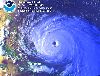
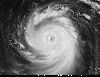
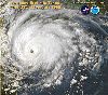
Pic 1.1: Disastrous Hurricane Floyd.
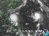
Pic 1.2: Hurricanes Dennis and Cindy meet (with information on the GOES-8 satellite that took the picture).
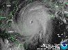
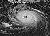
Pic 1.3: Hurricane Mitch devastates Central America.
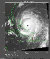
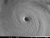
Pic 1.4: Hurricane Floyd again, with a well developed "eye".
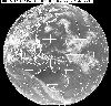
Pic 1.5: Typhoon Jelawat seen on a global scale (with explanation of the GMS-5 satellite that took the picture).
Pic 1.6: Hurricane Edouard.
SET 2: Hurricanes Linda, Bret, Andrew, Danielle, Madeline and Lester

ABOVE (reading left to right):
Pic 2.1: The Eye of Hurricane Linda (with pilot's report on flight inside the eye).
Pic 2.2: Hurricane Linda.
Pic 2.3: Hurricane Bret.
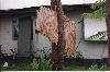
Pic 2.4: Tree trunk pierced by the winds of Hurricane Andrew.
Pic 2.5: Hurricane Danielle (with the story of the pilots who fly inside hurricanes).
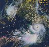
Pic 2.6: Hurricanes Madeline and Lester.
SET 3: Typhoons Ivan and Joan, Hurricane Tracks for 1998 and 1999, Hurricane Danger Areas
ABOVE (reading left to right):
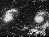
Pic 3.1: Typhoons Ivan and Joan.
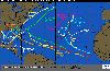
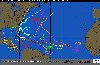
Pic 3.2: North Atlantic Hurricane tracks for 1998.
Pic 3.3: North Atlantic Hurricane tracks for 1999.
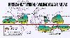
Pic 3.4: Hurricane Danger Areas.
WHAT IS A HURRICANE?
THE FACTS
These extremely dangerous weather systems are called hurricanes off the east and west coasts of the USA, cyclones over the Indian Ocean and Australia, and typhoons off Japan. Hurricanes cannot form closer than 300 miles to the equator.
High speed winds, occasionally reaching 350 kph or 200 mph, spiral around a calm low pressure "eye", often clearly seen in satellite photos. The eye can be 5 to 120 miles across but usually 20 to 40 miles. The whole storm is steered at a maximum of 25 mph by high-level winds. A tropical storm will only be classified as a hurricane if it is sustaining wind speeds above 74 mph (118 kph or Force 12 on the Beaufort Scale). Each year about 50 tropical storms reach hurricane status. The hurricane will be watched closely because of its potential to cause death and destruction. Satellite surveillance allows scientists to monitor the progress of a hurricane and aircraft are flown into the storm's interior to record wind speed, pressure, temperature etc.
HOW DO THEY FORM?
Sea surface temperatures must be above 26 deg C (80 deg F) for hurricane formation (therefore no hurricanes where I live, in the chilly UK). Air above warm tropical waters rises quickly as it is heated by the sea. As the air rises the earths rotation forces it to spin, creating an area of very low pressure in the centre or eye. The air cools rapidly as it rises, the water condenses out and forms huge cumulonimbus clouds. The hurricane moves across the ocean, bringing torrential rain and thunderstorms and very strong winds. Upon reaching land a hurricane may cause widespread damage for a few days but then, with no warm water to supply heat, the hurricane will die out.
WHAT IS THE STORM SURGE THAT CAUSE MAJOR FLOODING ALONG COASTLINES?
As well as causing damage with their violent winds, hurricanes also cause flooding on low lying coastlines due to the storm surge (a massive wave). The storm surge height for a hurricane can be from 6 to 10 metres (19 to 33 feet), or more. The surge is caused by winds pushing the ocean surface ahead of the storm. Coastal regions can also get battered by huge waves on top of the surge effect. In addition there can be flooding over land as a result of torrential rainfall that falls out of the storms cumulonimbus clouds.
Home